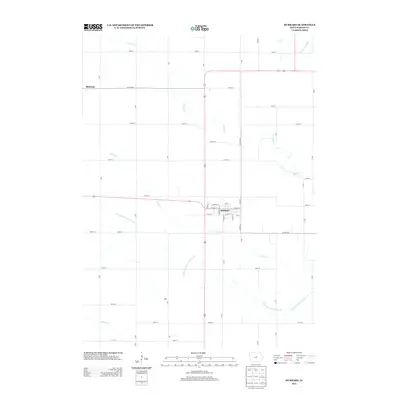
2013 Map of Hubbard
USGS Topo · Published 2013About this map
The town of Hubbard serves as the central hub of this Hardin County landscape, where the grid of local streets like S Minnesota St and E Maple St meets the rural agricultural surrounding. The territory is defined by its extensive drainage network, featuring engineered waterways such as Drainage Ditch Number 55 and Drainage Ditch Number 110, which support the intensive farming characteristic of this part of Iowa. These man-made channels complement natural watercourses like Honey Cr and the S Fork Iowa River in the northeast corner. Beyond the main town, smaller named points such as Sherman and Idaho mark the map, indicating the dispersed settlement pattern of the region. The map also documents the essential road infrastructure, ranging from US routes to local avenues like G Ave and KK Ave, which connect the remote farmsteads to the commercial center.
Find a feature on this map
48 named features on this map. Tap any name to fly to it.
Don’t see what you’re looking for? This feature index may not catch every label — zoom into the map to look around manually.
Map Details
Editions of this 2013 Hubbard Map
This is the sole edition of this map. No revisions or reprints were ever made.
Other maps of this area

1954 · Waterloo
USGS Topo · 1:250,000

1955 · Waterloo
USGS Topo · 1:250,000

1975 · State Center NW
USGS Topo · 1:24,000

1975 · Zearing
USGS Topo · 1:24,000

1975 · Mc Callsburg
USGS Topo · 1:24,000

1979 · Buckeye West
USGS Topo · 1:24,000

1979 · Buckeye East
USGS Topo · 1:24,000

1979 · New Providence
USGS Topo · 1:24,000

1979 · Hubbard
USGS Topo · 1:24,000
1979 · Radcliffe
USGS Topo · 1:24,000