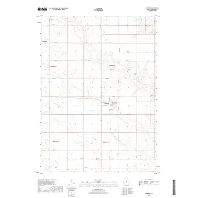
2018 Map of Hubbard
USGS Topo · Published 2018About this map
Hubbard serves as the central hub for this portion of Hardin County, appearing here in the late 2010s. The landscape is defined by the headwaters and meandering courses of several prairie streams, including Tipton Cr and Honey Cr, which eventually lead toward the S Fork Iowa River in the northeast. This area illustrates the intensive agricultural drainage patterns of the Iowa plains, evidenced by engineered waterways such as Drainage Ditch Number 55 and Drainage Ditch Number 110. For those researching local heritage, the map provides precise locations for several rural burying grounds, from the Sherman Township Cem in the northwest to the Idaho Cem and Tipton Grove Cem further south and east. The grid of country roads, including Co RD s27 and Co RD d55, connects the dispersed farmsteads and the smaller community of Sherman to the larger street grid of Hubbard.
Find a feature on this map
34 named features on this map. Tap any name to fly to it.
Don’t see what you’re looking for? This feature index may not catch every label — zoom into the map to look around manually.
Map Details
Editions of this 2018 Hubbard Map
This is the sole edition of this map. No revisions or reprints were ever made.
Other maps of this area

1954 · Waterloo
USGS Topo · 1:250,000

1955 · Waterloo
USGS Topo · 1:250,000

1975 · State Center NW
USGS Topo · 1:24,000

1975 · Zearing
USGS Topo · 1:24,000

1975 · Mc Callsburg
USGS Topo · 1:24,000

1979 · Buckeye West
USGS Topo · 1:24,000

1979 · Buckeye East
USGS Topo · 1:24,000

1979 · New Providence
USGS Topo · 1:24,000

1979 · Hubbard
USGS Topo · 1:24,000
1979 · Radcliffe
USGS Topo · 1:24,000