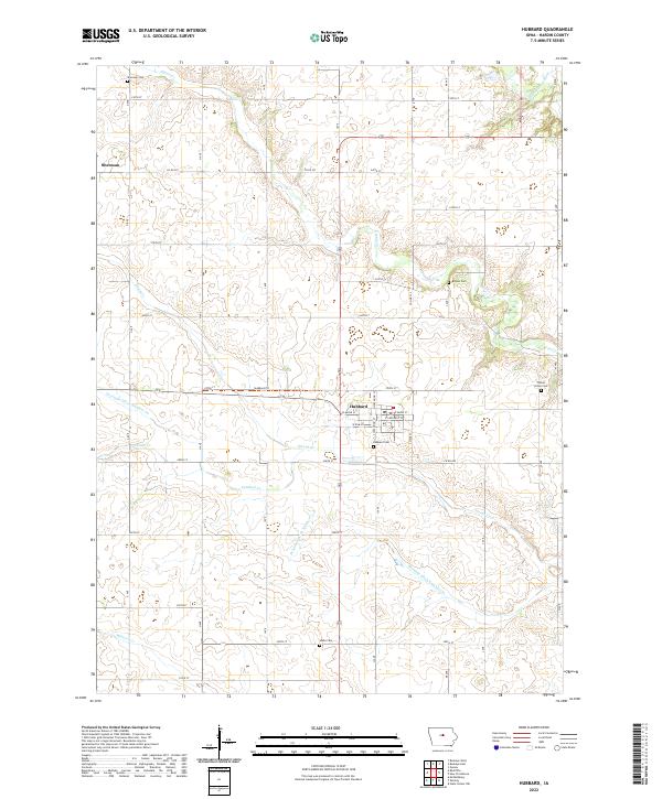
2022 Map of Hubbard
USGS Topo · Published 2022About this map
The town of Hubbard serves as the central hub of this agricultural landscape in Hardin County, Iowa. The rectilinear grid of the township system is clearly defined by numerous county roads and street alignments such as 270th St and Hubbard Trail. This survey illustrates a highly developed rural drainage network essential for prairie farming, featuring Drainage Ditch Number 55 and Drainage Ditch Number 110 alongside natural watercourses like Honey Creek and Cardinal Creek. For genealogists, the map identifies several distinct burial grounds scattered across the countryside, including the Idaho Cemetery to the south and the Sherman Cemetery near the small settlement of Sherman in the northwest. The presence of the South Fork Iowa River in the northeastern corner provides a contrast to the engineered drainage systems found elsewhere in the quadrangle.
Find a feature on this map
37 named features on this map. Tap any name to fly to it.
Don’t see what you’re looking for? This feature index may not catch every label — zoom into the map to look around manually.
Map Details
Editions of this 2022 Hubbard Map
This is the sole edition of this map. No revisions or reprints were ever made.
Other maps of this area

1954 · Waterloo
USGS Topo · 1:250,000

1955 · Waterloo
USGS Topo · 1:250,000

1975 · State Center NW
USGS Topo · 1:24,000

1975 · Zearing
USGS Topo · 1:24,000

1975 · Mc Callsburg
USGS Topo · 1:24,000

1979 · Buckeye West
USGS Topo · 1:24,000

1979 · Buckeye East
USGS Topo · 1:24,000

1979 · New Providence
USGS Topo · 1:24,000

1979 · Hubbard
USGS Topo · 1:24,000
1979 · Radcliffe
USGS Topo · 1:24,000