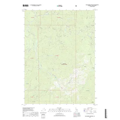
2018 Map of Huckleberry Mountain
USGS Topo · Published 2018About this map
Klamath National Forest dominates this landscape in western Siskiyou County, where the topography is defined by high ridgelines and a complex network of drainages. The Pacific Crest National Scenic Trail winds along the eastern edge of the quadrangle, traversing the steep slopes of Huckleberry Mtn and Buckhorn Mtn. This area serves as a critical watershed, with Elk Creek and its many tributaries, such as Lick Creek and Stanza Cr, carving deep valleys through the terrain. The presence of Sulphur Spring and several named flats and hollows, such as Malone Flat and Coon Hollow, indicates specific points of local interest or historical stopping points for travelers and foresters. To the southeast, the terrain rises toward the Marble Mountains, while the open expanse of Green Valley provides a distinct break from the surrounding ridges.
Find a feature on this map
37 named features on this map. Tap any name to fly to it.
Don’t see what you’re looking for? This feature index may not catch every label — zoom into the map to look around manually.
Map Details
Editions of this 2018 Huckleberry Mountain Map
This is the sole edition of this map. No revisions or reprints were ever made.
Other maps of this area

1914 · Seiad
USGS Topo · 1:125,000

1922 · Seiad
USGS Topo · 1:125,000

1948 · Weed
USGS Topo · 1:250,000

1950 · Weed
USGS Topo · 1:250,000

1955 · Seiad Valley
USGS Topo · 1:62,500

1955 · Ukonom Lake
USGS Topo · 1:62,500

1955 · Scott Bar
USGS Topo · 1:62,500

1956 · Happy Camp
USGS Topo · 1:62,500

1958 · Weed
USGS Topo · 1:250,000

1963 · Weed
USGS Topo · 1:250,000