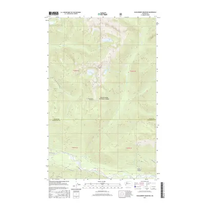
2017 Map of Huckleberry Mountain
USGS Topo · Published 2017About this map
Hurricane Peak and the high ridges of Huckleberry Mountain dominate this section of the Mount Baker National Forest on the border of Skagit and Snohomish Counties. The landscape is defined by a dense network of high-altitude water bodies, including Chaval Lake, Crater Lake, and the adjacent Lake Kawkawak and Lake Toketie. These alpine basins feed numerous drainages such as Big Cr and Buck Cr, which eventually descend toward the Suiattle River corridor in the south.
Find a feature on this map
30 named features on this map. Tap any name to fly to it.
Don’t see what you’re looking for? This feature index may not catch every label — zoom into the map to look around manually.
Map Details
Editions of this 2017 Huckleberry Mountain Map
This is the sole edition of this map. No revisions or reprints were ever made.
Other maps of this area

1899 · Glacier Peak
USGS Topo · 1:125,000

1901 · Glacier Peak
USGS Topo · 1:125,000

1950 · Glacier Peak
USGS Topo · 1:62,500

1955 · Concrete
USGS Topo · 1:250,000

1958 · Concrete
USGS Topo · 1:250,000

1962 · Concrete
USGS Topo · 1:250,000

1963 · Sonny Boy Lakes
USGS Topo · 1:24,000
1963 · Downey Mtn
USGS Topo · 1:24,000
1966 · Snowking Mtn.
USGS Topo · 1:24,000
1966 · Huckleberry Mtn
USGS Topo · 1:24,000