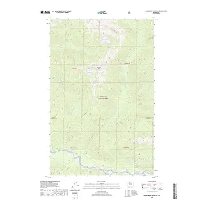
2020 Map of Huckleberry Mountain
USGS Topo · Published 2020About this map
Hurricane Peak and the high ridges of Huckleberry Mtn dominate this alpine landscape within the Mount Baker National Forest. The map captures a rugged transition from mountain summits down to the Suiattle River valley, which is protected here as the Skagit Wild and Scenic River. Numerous high-altitude basins hold isolated water bodies like Chaval Lake, Crater Lake, and the small Lake Kawawak, reflecting the complex glacial topography of the North Cascades. Along the river corridor, landmarks like Gibson Falls and the Green Mountain Pasture indicate the few accessible points in this wilderness. The terrain is defined by steep drainage systems, including Buck Creek, Tenas Cr, and Circle Cr, which feed the major river system at the southern edge of the survey.
Find a feature on this map
27 named features on this map. Tap any name to fly to it.
Don’t see what you’re looking for? This feature index may not catch every label — zoom into the map to look around manually.
Map Details
Editions of this 2020 Huckleberry Mountain Map
This is the sole edition of this map. No revisions or reprints were ever made.
Other maps of this area

1899 · Glacier Peak
USGS Topo · 1:125,000

1901 · Glacier Peak
USGS Topo · 1:125,000

1950 · Glacier Peak
USGS Topo · 1:62,500

1955 · Concrete
USGS Topo · 1:250,000

1958 · Concrete
USGS Topo · 1:250,000

1962 · Concrete
USGS Topo · 1:250,000

1963 · Sonny Boy Lakes
USGS Topo · 1:24,000
1963 · Downey Mtn
USGS Topo · 1:24,000
1966 · Snowking Mtn.
USGS Topo · 1:24,000
1966 · Huckleberry Mtn
USGS Topo · 1:24,000