2023 Map of Hudson Falls
USGS Topo · Published 2023About this map
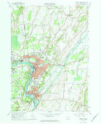
Hudson Falls and Fort Edward define the industrial and civic heart of this Washington County landscape, where the Hudson River bends sharply near Bakers Falls. The area's deep connection to nineteenth-century transport is visible in the remaining traces of the Old Champlain Canal and the Glens Falls Feeder Canal, which once powered the local economy and connected these river towns to broader markets. The settlement pattern is anchored by institutions like the Washington County Courthouse and historic burial grounds, including Union Cem and Moss Street Cem. To the north, the terrain transitions into the agricultural hamlets of Kingsbury and Vaughns Corners, while the western edge is marked by the Floyd Bennett Memorial Airport. The river itself remains the dominant feature, flowing past Rogers Island and through a network of reservoirs like Christie Reservoir and Sardersberg Reservoir.
Find a feature on this map
125 named features on this map. Tap any name to fly to it.
Don’t see what you’re looking for? This feature index may not catch every label — zoom into the map to look around manually.
Map Details
Editions of this 2023 Hudson Falls Map
This is the sole edition of this map. No revisions or reprints were ever made.