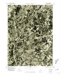
1977 Map of Hudson
USGS Topo · Published 1981About this map
The Hudson town center and the winding Assabet River anchor this 1977 orthophotograph, which captures a period of significant suburban expansion and land-use shifts in Middlesex County. The high-contrast aerial imagery reveals the dense residential clusters of Hudson and Stow as they existed before the tech-corridor boom fully reshaped the region. North of the river, the landscape transitions into the more dispersed wooded and agricultural patterns of Boxboro, Harvard, and Bolton. Significant for its visual evidence of late-1970s development, the map shows the footprint of older industrial sites along the river alongside newer residential subdivisions and the cleared paths of major transportation routes. Smaller locales like East Bolton and East Berlin appear as distinct pockets within the larger rural-suburban matrix of the day.
Find a feature on this map
8 named features on this map. Tap any name to fly to it.
Don’t see what you’re looking for? This feature index may not catch every label — zoom into the map to look around manually.
Map Details
Editions of this 1977 Hudson Map
This is the sole edition of this map. No revisions or reprints were ever made.
Other maps of this area

1886 · Lowell
USGS Topo · 1:62,500

1886 · Framingham
USGS Topo · 1:62,500

1887 · Marlboro
USGS Topo · 1:62,500

1889 · Marlboro
USGS Topo · 1:62,500

1889 · Framingham
USGS Topo · 1:62,500

1893 · Lowell
USGS Topo · 1:62,500

1893 · Groton
USGS Topo · 1:62,500

1894 · Framingham
USGS Topo · 1:62,500

1896 · Marlboro
USGS Topo · 1:62,500

1898 · Marlboro
USGS Topo · 1:62,500