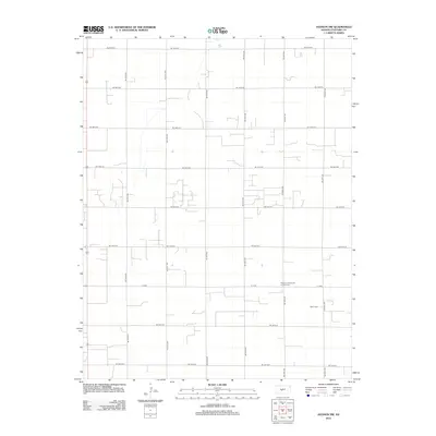
2012 Map of Hudson NW
USGS Topo · Published 2012About this map
Agricultural patterns and a strict rectangular road network define this portion of Stafford County in the early 21st century. The landscape is segmented by a precise grid of local roads, such as NE 10th Ave and NE 200th St, which facilitate access to the expansive farmsteads of the Kansas plains. Central to the area's social history is the Peace United Church of Christ Cem, located along K 19 Rd, serving as a focal point for the local community. Further south, the Salem Cem marks another site of genealogical importance near NE 60th Ave. This survey illustrates the enduring structure of rural Kansas life, where transportation and community sites remain closely tied to the section lines established during early settlement.
Find a feature on this map
18 named features on this map. Tap any name to fly to it.
Don’t see what you’re looking for? This feature index may not catch every label — zoom into the map to look around manually.
Map Details
Editions of this 2012 Hudson NW Map
This is the sole edition of this map. No revisions or reprints were ever made.
Other maps of this area

1891 · Great Bend
USGS Topo · 1:125,000

1893 · Great Bend
USGS Topo · 1:125,000

1955 · Great Bend
USGS Topo · 1:250,000

1957 · Great Bend
USGS Topo · 1:250,000

1957 · Ellinwood SW
USGS Topo · 1:24,000

1957 · Ellinwood
USGS Topo · 1:24,000

1958 · Great Bend
USGS Topo · 1:250,000

1958 · Great Bend
USGS Topo · 1:24,000
1970 · Hudson NW
USGS Topo · 1:24,000
1970 · Seward
USGS Topo · 1:24,000