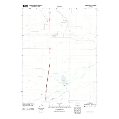
2010 Map of Huerfano Butte
USGS Topo · Published 2010About this map
Apache City stands as a primary point of reference in this high-desert landscape of southern Colorado, where the management of water defines the patterns of settlement. The terrain is characterized by a sophisticated network of irrigation and storage, including the Bradford Canal and Homestead Canal, which draw from the Huerfano River to support the arid surroundings. Notable infrastructure such as Orlando Reservoir Number 2 and its associated dam illustrate the region's historical reliance on engineering to capture seasonal runoff from drainages like Greasewood Arroyo. For those researching local history or genealogy, the presence of Speed Cemetery and Butte Cemetery provides tangible links to the area's early residents. The prominent volcanic plug of Huerfano Butte rises as a landmark near the river, overlooking a complex system of creeks and arroyos including Apache Creek and Butte Creek that converge toward the valley floor.
Find a feature on this map
20 named features on this map. Tap any name to fly to it.
Don’t see what you’re looking for? This feature index may not catch every label — zoom into the map to look around manually.
Map Details
Editions of this 2010 Huerfano Butte Map
This is the sole edition of this map. No revisions or reprints were ever made.
Other maps of this area

1891 · Walsenburg
USGS Topo · 1:125,000

1894 · Walsenburg
USGS Topo · 1:125,000

1897 · Walsenburg
USGS Topo · 1:125,000

1900 · Walsenburg
USGS Topo · 1:125,000

1954 · Trinidad
USGS Topo · 1:250,000

1955 · Trinidad
USGS Topo · 1:250,000

1958 · Trinidad
USGS Topo · 1:250,000

1959 · Trinidad
USGS Topo · 1:250,000
1963 · Walsenburg North
USGS Topo · 1:24,000
1963 · Maria Reservoir
USGS Topo · 1:24,000