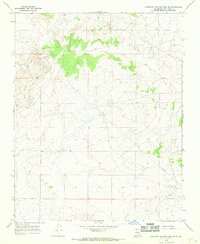
1966 Map of Huerfano Trading Post SW
USGS Topo · Published 1969About this map
Navajo Miracle Ch stands as a focal point in this high desert landscape of northwestern New Mexico, surrounded by the industrial infrastructure of the late 1960s. The map document reveals a transition between the natural drainage patterns of Alamo Wash and De-na-zin Wash and the expanding energy footprint of the Bisti Oil Field. This era of development is marked by a network of infrastructure including a prominent Pipeline, a Pumping Sta, and numerous scattered extractions such as the G L O No 5 site. The topography is defined by complex arroyos and washes that cut through the terrain, illustrating the interplay between the arid geography of San Juan County and the mid-century push for natural resources. Researchers can find precise locations for several Oil Wells and Drill Holes that dot the landscape during this period of active exploration.
Find a feature on this map
10 named features on this map. Tap any name to fly to it.
Don’t see what you’re looking for? This feature index may not catch every label — zoom into the map to look around manually.
Map Details
Editions of this 1966 Huerfano Trading Post SW Map
This is the sole edition of this map. No revisions or reprints were ever made.
Other maps of this area

1889 · Largo
USGS Topo · 1:250,000

1889 · Chaco
USGS Topo · 1:250,000

1892 · Chaco
USGS Topo · 1:250,000

1895 · Largo
USGS Topo · 1:250,000

1954 · Shiprock
USGS Topo · 1:250,000

1954 · Aztec
USGS Topo · 1:250,000

1958 · Shiprock
USGS Topo · 1:250,000

1958 · Aztec
USGS Topo · 1:250,000

1959 · Shiprock
USGS Topo · 1:250,000

1962 · Aztec
USGS Topo · 1:250,000