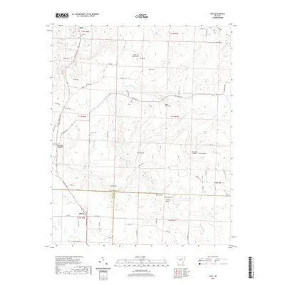
2020 Map of Huff
USGS Topo · Published 2020About this map
Salado Mountain and Uncle Joe Warren Mountain overlook a landscape where the upland ridges of the Ozarks meet the flatter drainages of the White County and Jackson County lines. This survey documents the rural character of the area around Pleasant Plains, where the settlement pattern follows the high ground along Batesville Boulevard. The map is particularly useful for genealogical research, identifying numerous family-associated burial grounds including Huff Cem, Riddles Cem, and Price Cem. Steep hollows like Howl Hollow and Turkey Pen Hollow cut through the terrain, leading down toward the many small waterways such as Departee Creek and Piney Creek that define the local watershed.
Find a feature on this map
82 named features on this map. Tap any name to fly to it.
Don’t see what you’re looking for? This feature index may not catch every label — zoom into the map to look around manually.
Map Details
Editions of this 2020 Huff Map
This is the sole edition of this map. No revisions or reprints were ever made.
Other maps of this area

1890 · Batesville
USGS Topo · 1:125,000

1891 · Batesville
USGS Topo · 1:125,000

1935 · Newport
USGS Topo · 1:62,500

1935 · Augusta
USGS Topo · 1:62,500

1935 · Bald Knob
USGS Topo · 1:62,500

1942 · Jamestown
USGS Topo · 1:31,680

1942 · Salado
USGS Topo · 1:31,680

1953 · Memphis
USGS Topo · 1:250,000

1956 · Memphis
USGS Topo · 1:250,000
1956 · Newark
USGS Topo · 1:24,000