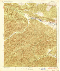
1937 Map of Hughes Lake
USGS Topo · Published 1937About this map
The San Andreas Rift Zone forms the dominant structural axis of this 1937 survey, cutting a distinctive diagonal through the high country of the Angeles National Forest. Along this seismic depression, a series of sag ponds and valley settlements established a remote corridor of ranching and early mountain commerce. The map centers on the community of Lake Hughes P.O. and the waters of Hughes Lake and Elizabeth Lake, where topography and water rights dictated the placement of homesteads like Munz Ranch.
Find a feature on this map
25 named features on this map. Tap any name to fly to it.
Don’t see what you’re looking for? This feature index may not catch every label — zoom into the map to look around manually.
Map Details
Editions of this 1937 Hughes Lake Map
2 editions found
Other maps of this area

1903 · Tejon
USGS Topo · 1:125,000

1915 · Elizabeth Lake
USGS Topo · 1:125,000

1917 · Elizabeth Lake
USGS Topo · 1:125,000

1931 · Red Mountain
USGS Topo · 1:24,000

1931 · Warm Spring
USGS Topo · 1:24,000

1931 · Little Buttes
USGS Topo · 1:24,000
1932 · La Brun
USGS Topo · 1:24,000

1932 · Lake
USGS Topo · 1:24,000
1932 · Mint Canyon
USGS Topo · 1:24,000

1932 · Hughes Lake
USGS Topo · 1:24,000