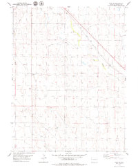
1979 Map of Hugo SW
USGS Topo · Published 1979About this map
Big Sandy Creek winds through this Lincoln County landscape, defining the local hydrology and settlement patterns in the late 1970s. The Union Pacific railroad corridor cuts a sharp diagonal across the northeastern corner, marking the primary transportation artery for the region. Evidence of rural infrastructure is found at Liberty Cem, a key landmark for genealogical research and local history. The terrain is dotted with several natural water sources, including a Spring and multiple Springs, which likely served as vital points for early ranching and agriculture. Industrial activity is represented by a Gravel Pit and Well near the rail line, while a prominent Radio Tower and an extensive underground Pipeline represent the modern utility footprint that characterized the area during this era of U.S. Geological Survey mapping.
Find a feature on this map
12 named features on this map. Tap any name to fly to it.
Don’t see what you’re looking for? This feature index may not catch every label — zoom into the map to look around manually.
Map Details
Editions of this 1979 Hugo SW Map
This is the sole edition of this map. No revisions or reprints were ever made.
Other maps of this area

1889 · Sanborn
USGS Topo · 1:125,000

1891 · Sanborn
USGS Topo · 1:125,000

1891 · Arroyo
USGS Topo · 1:125,000

1891 · Limon
USGS Topo · 1:125,000

1892 · Limon
USGS Topo · 1:125,000

1893 · Arroyo
USGS Topo · 1:125,000

1893 · Sanborn
USGS Topo · 1:125,000

1954 · Limon
USGS Topo · 1:250,000

1954 · Lamar
USGS Topo · 1:250,000

1957 · Limon
USGS Topo · 1:250,000