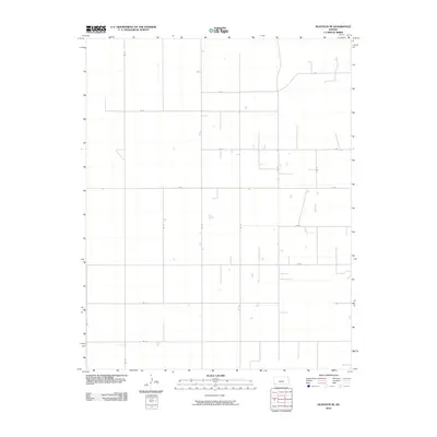
2010 Map of Hugoton SE
USGS Topo · Published 2010About this map
Stevens County’s High Plains landscape is defined by a rigorous grid of agricultural access roads in this 2010 survey of the Hugoton area. The terrain is notably sparse, focused on the utility of the land rather than concentrated settlements. Major north-south arteries like Rd 12 and Rd 16 intersect with east-west routes such as Rd H and Rd F, forming a precise geometry typical of the American West's rural development. This network supports the region's agricultural and industrial infrastructure, with various unnamed depressions and basins scattered across the sections, suggesting the ephemeral water storage common in this semi-arid part of Kansas. The dominance of lettered and numbered routes like Rd J and Rd 17 reflects a landscape organized for high-efficiency transit between farmsteads and distant markets.
Find a feature on this map
18 named features on this map. Tap any name to fly to it.
Don’t see what you’re looking for? This feature index may not catch every label — zoom into the map to look around manually.
Map Details
Editions of this 2010 Hugoton SE Map
This is the sole edition of this map. No revisions or reprints were ever made.
Other maps of this area

1954 · Perryton
USGS Topo · 1:250,000

1955 · Dodge City
USGS Topo · 1:250,000

1958 · Perryton
USGS Topo · 1:250,000

1958 · Dodge City
USGS Topo · 1:250,000

1959 · Dodge City
USGS Topo · 1:250,000

1967 · Straight
USGS Topo · 1:24,000

1967 · Straight NE
USGS Topo · 1:24,000

1967 · Hooker NW
USGS Topo · 1:24,000
1974 · Hugoton SE
USGS Topo · 1:24,000

1974 · Hugoton
USGS Topo · 1:24,000