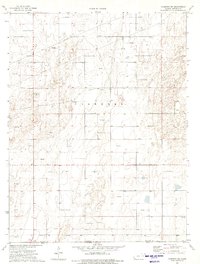
1974 Map of Hugoton SW
USGS Topo · Published 1975About this map
Voorhees defines the physical landscape of this High Plains region, where the vast, open terrain is marked by the industrial infrastructure of the mid-1970s. The map illustrates the intensive development of the Hugoton gas field, evidenced by the proliferation of dozens of Gas Wells that dot the prairie. This resource extraction network is tied together by a complex system of Pipelines cutting across section lines. The map also documents a significant political boundary where Stevens County and Texas County meet at the Kansas-Oklahoma state line. This borderland perspective shows how the rectangular survey system imposes order on the semi-arid landscape, creating a grid of roads and property lines that ignore the underlying topography.
Find a feature on this map
5 named features on this map. Tap any name to fly to it.
Don’t see what you’re looking for? This feature index may not catch every label — zoom into the map to look around manually.
Map Details
Editions of this 1974 Hugoton SW Map
This is the sole edition of this map. No revisions or reprints were ever made.
Other maps of this area

1954 · Perryton
USGS Topo · 1:250,000

1955 · Dodge City
USGS Topo · 1:250,000

1958 · Perryton
USGS Topo · 1:250,000

1958 · Dodge City
USGS Topo · 1:250,000

1959 · Dodge City
USGS Topo · 1:250,000

1967 · Straight
USGS Topo · 1:24,000

1967 · Straight NE
USGS Topo · 1:24,000

1973 · Rolla NE
USGS Topo · 1:24,000

1973 · Hough NE
USGS Topo · 1:24,000
1974 · Rolla SE
USGS Topo · 1:24,000