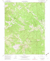
1967 Map of Hull Mountain
USGS Topo · Published 1983About this map
Hull Mountain anchors this 1967 survey of the high country where Mendocino, Glenn, and Lake counties converge. This landscape within the Mendocino National Forest is defined by a network of seasonal outposts and primitive access routes, including Cushman Camp, Goat Camp, and the well-marked Jeep Trail winding through the ridges. The upper reaches of the Eel River and its numerous tributaries like Skidmore Creek and Panther Creek illustrate a remote terrain managed for both recreation and conservation, noted by the presence of a State Game Refuge in the southern half. Small alpine water bodies such as Cushman Lake, Barley Lake, and Turtle Lake dot the ridges, while specific human landmarks like Graves Cabin and the Lookout station provide points of interest for researchers of local forest history and regional land use during the mid-twentieth century.
Find a feature on this map
53 named features on this map. Tap any name to fly to it.
Don’t see what you’re looking for? This feature index may not catch every label — zoom into the map to look around manually.
Map Details
Editions of this 1967 Hull Mountain Map
2 editions found
Other maps of this area

1922 · Hullville
USGS Topo · 1:62,500

1929 · Eden Valley
USGS Topo · 1:62,500

1943 · Pomo
USGS Topo · 1:62,500

1951 · Lake Pillsbury
USGS Topo · 1:62,500

1952 · Hull Mountain
USGS Topo · 1:62,500

1952 · Eden Valley
USGS Topo · 1:62,500

1957 · Ukiah
USGS Topo · 1:250,000

1960 · Ukiah
USGS Topo · 1:250,000

1960 · Potter Valley
USGS Topo · 1:62,500
1966 · Sanhedrin Mtn
USGS Topo · 1:24,000