
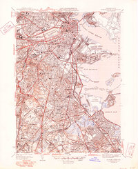
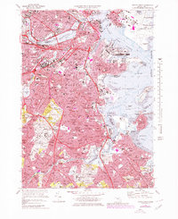
1949 Map of Hull
USGS Topo · Published 1958This historical map portrays the area of Hull in 1949, primarily covering Suffolk County as well as portions of Norfolk County and Plymouth County. Featuring a scale of 1:24000, this map provides a highly detailed snapshot of the terrain, roads, buildings, counties, and historical landmarks in the Hull region at the time. Published in 1958, it is the sole known edition of this map.
Map Details
Editions of this 1949 Hull Map
This is the sole edition of this map. No revisions or reprints were ever made.
Historical Maps of Weymouth Through Time
14 maps found

1944 Boston South
Suffolk County, MA

1944 Hull
Suffolk County, MA
1946 Boston South
Suffolk County, MA
1946 Hull
Suffolk County, MA

1948 Hull
Suffolk County, MA
1949 Hull
Suffolk County, MA

1954 Boston South
Suffolk County, MA
1956 Boston South
Suffolk County, MA
1958 Hull
Suffolk County, MA
1970 Boston South
Suffolk County, MA
1971 Hull
Suffolk County, MA

1977 Boston South
Suffolk County, MA

1977 Hull
Suffolk County, MA
1987 Boston South
Suffolk County, MA