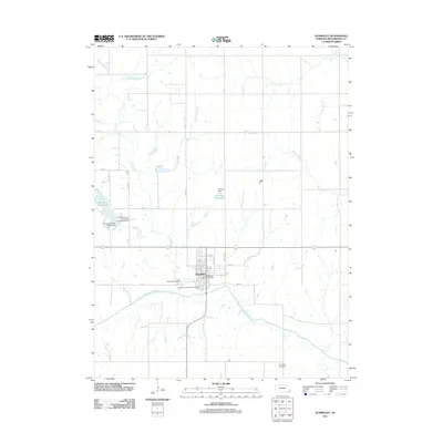
2011 Map of Humboldt
USGS Topo · Published 2011About this map
The town of Humboldt serves as the focal point of this Richardson County landscape, situated along the northern banks of the North Fork Big Nemaha River. The area's agricultural and recreational character is defined by its water systems, including the serpentine paths of Whisky Run, Long Branch, and Crooked Branch. To the west, Kirkmans Cove Lake and the Kirkmans Cove Recreation Area Campground mark a significant local recreation site, while the central town grid features the Humboldt Post Office and Humboldt Cemetery. The terrain is punctuated by small-scale infrastructure such as Yearling Dam and the Yearling Reservoir. Genealogists and local historians can trace the rural distribution of family lands and community spaces, from the municipal Humboldt Lake Park Campground to the more isolated Lynchburg Cemetery to the southeast, illustrating how the community is anchored by both its watercourses and its historic civic markers.
Find a feature on this map
32 named features on this map. Tap any name to fly to it.
Don’t see what you’re looking for? This feature index may not catch every label — zoom into the map to look around manually.
Map Details
Editions of this 2011 Humboldt Map
This is the sole edition of this map. No revisions or reprints were ever made.
Other maps of this area

1915 · Howe
USGS Topo · 1:62,500

1916 · Humboldt
USGS Topo · 1:62,500

1955 · Nebraska City
USGS Topo · 1:250,000

1955 · Lincoln
USGS Topo · 1:250,000

1957 · Nebraska City
USGS Topo · 1:250,000

1957 · Lincoln
USGS Topo · 1:250,000

1958 · Lincoln
USGS Topo · 1:250,000

1958 · Nebraska City
USGS Topo · 1:250,000

1965 · Table Rock
USGS Topo · 1:24,000
1965 · Tecumseh SE
USGS Topo · 1:24,000