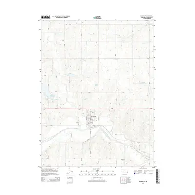
2014 Map of Humboldt
USGS Topo · Published 2014About this map
The town of Humboldt serves as the focal point of this Richardson County landscape, where the local street grid meets a series of rural routes. To the west, Kirkmans Cove Lake and the smaller Yearling Reservoir provide notable water features within the rolling terrain. The hydrological character of the region is defined by the North Fork Big Nemaha River, which winds across the southern portion of the quadrangle, fed by numerous tributaries including Whisky Run, Round Grove Cr, and Long Br. For those tracing local heritage, the map identifies the Humboldt Cem just south of town and the Lynchburg Cem situated further southeast, offering critical geographic markers for genealogical research. The grid-like arrangement of section roads, such as 714 RD and 634 Ave, illustrates the enduring organization of Nebraska’s agricultural heartland in the early 21st century.
Find a feature on this map
55 named features on this map. Tap any name to fly to it.
Don’t see what you’re looking for? This feature index may not catch every label — zoom into the map to look around manually.
Map Details
Editions of this 2014 Humboldt Map
This is the sole edition of this map. No revisions or reprints were ever made.
Other maps of this area

1915 · Howe
USGS Topo · 1:62,500

1916 · Humboldt
USGS Topo · 1:62,500

1955 · Nebraska City
USGS Topo · 1:250,000

1955 · Lincoln
USGS Topo · 1:250,000

1957 · Nebraska City
USGS Topo · 1:250,000

1957 · Lincoln
USGS Topo · 1:250,000

1958 · Lincoln
USGS Topo · 1:250,000

1958 · Nebraska City
USGS Topo · 1:250,000

1965 · Table Rock
USGS Topo · 1:24,000
1965 · Tecumseh SE
USGS Topo · 1:24,000