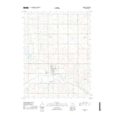
2017 Map of Humboldt
USGS Topo · Published 2017About this map
Humboldt serves as the central hub of this Richardson County landscape, situated just north of the North Fork Big Nemaha River. The town's grid is clearly defined, anchored by the Humboldt Cem on its western edge. The surrounding terrain is heavily influenced by a network of waterways including Whisky Run, Long Br, and Porter Br, which feed into the primary river valley. These water sources supported the agricultural development of the region, evident in the numerous section roads like 714 RD and 715 RD that carve the prairie into precise townships.
Find a feature on this map
29 named features on this map. Tap any name to fly to it.
Don’t see what you’re looking for? This feature index may not catch every label — zoom into the map to look around manually.
Map Details
Editions of this 2017 Humboldt Map
This is the sole edition of this map. No revisions or reprints were ever made.
Other maps of this area

1915 · Howe
USGS Topo · 1:62,500

1916 · Humboldt
USGS Topo · 1:62,500

1955 · Nebraska City
USGS Topo · 1:250,000

1955 · Lincoln
USGS Topo · 1:250,000

1957 · Nebraska City
USGS Topo · 1:250,000

1957 · Lincoln
USGS Topo · 1:250,000

1958 · Lincoln
USGS Topo · 1:250,000

1958 · Nebraska City
USGS Topo · 1:250,000

1965 · Table Rock
USGS Topo · 1:24,000
1965 · Tecumseh SE
USGS Topo · 1:24,000