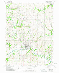
1965 Map of Humboldt
USGS Topo · Published 1967About this map
The town of Humboldt serves as the central hub of this Richardson County survey, situated at the confluence of the North Fork Big Nemaha River and its various tributaries. The landscape is defined by the heavy infrastructure of the Chicago Burlington and Quincy railroad, which follows the river valley past a gaging station and several gravel pits. Agricultural and civic life in the mid-1960s is evidenced by the presence of the Pine Ridge Sch and the Humboldt Municipal Airport just east of the town center.
Find a feature on this map
26 named features on this map. Tap any name to fly to it.
Don’t see what you’re looking for? This feature index may not catch every label — zoom into the map to look around manually.
Map Details
Editions of this 1965 Humboldt Map
This is the sole edition of this map. No revisions or reprints were ever made.
Other maps of this area

1915 · Howe
USGS Topo · 1:62,500

1916 · Humboldt
USGS Topo · 1:62,500

1955 · Nebraska City
USGS Topo · 1:250,000

1955 · Lincoln
USGS Topo · 1:250,000

1957 · Nebraska City
USGS Topo · 1:250,000

1957 · Lincoln
USGS Topo · 1:250,000

1958 · Lincoln
USGS Topo · 1:250,000

1958 · Nebraska City
USGS Topo · 1:250,000

1965 · Table Rock
USGS Topo · 1:24,000
1965 · Tecumseh SE
USGS Topo · 1:24,000