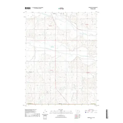
2017 Map of Humboldt SE
USGS Topo · Published 2017About this map
Dawson and the smaller settlement of Nim City anchor this portion of Richardson County, where the hydrology of the Big Nemaha River system dominates the landscape. The map reveals the complex drainage patterns of the North Fork Big Nemaha River and the South Fork Big Nemaha River, including the distinct Old Channel South Fork Nemaha River. This network of tributaries, such as Honey Cr and Rattlesnake Cr, illustrates how water movement has shaped the agricultural layout of the region. Local history and genealogy researchers will find two significant burial sites preserved on the landscape: Iliff Cem near the northern border and Wild Rose Cem to the south. The transition from river bottomlands to the surrounding uplands is further marked by numerous minor waterways like Barneys Br and Cottonwood Cr, reflecting the drainage challenges faced by early settlers in this southeastern corner of the state.
Find a feature on this map
36 named features on this map. Tap any name to fly to it.
Don’t see what you’re looking for? This feature index may not catch every label — zoom into the map to look around manually.
Map Details
Editions of this 2017 Humboldt SE Map
This is the sole edition of this map. No revisions or reprints were ever made.
Other maps of this area

1888 · Hiawatha
USGS Topo · 1:125,000

1894 · Hiawatha
USGS Topo · 1:125,000

1915 · Falls City
USGS Topo · 1:62,500

1916 · Humboldt
USGS Topo · 1:62,500

1950 · Kansas City
USGS Topo · 1:250,000

1954 · Kansas City
USGS Topo · 1:250,000

1955 · Nebraska City
USGS Topo · 1:250,000

1956 · Kansas City
USGS Topo · 1:250,000

1957 · Nebraska City
USGS Topo · 1:250,000

1958 · Nebraska City
USGS Topo · 1:250,000