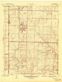
1942 Map of Hume
USGS Topo · Published 1942About this map
Hume serves as the central hub of this Missouri-Kansas border landscape as it appeared just before the mid-twentieth century. The community is anchored by the Kansas City Southern railroad line, which bisects the region north to south. This area demonstrates a highly developed rural school system, with numerous neighborhood institutions such as Mt Leonard Sch, Brush College Sch, and Prairie Union Sch serving local families.
Find a feature on this map
27 named features on this map. Tap any name to fly to it.
Don’t see what you’re looking for? This feature index may not catch every label — zoom into the map to look around manually.
Map Details
Editions of this 1942 Hume Map
2 editions found

Other maps of this area

1884 · Fort Scott
USGS Topo · 1:125,000

1886 · Nevada
USGS Topo · 1:125,000

1886 · Fort Scott
USGS Topo · 1:125,000

1887 · Butler
USGS Topo · 1:125,000

1887 · Mound City
USGS Topo · 1:125,000

1893 · Fort Scott
USGS Topo · 1:125,000

1893 · Mound City
USGS Topo · 1:125,000

1894 · Butler
USGS Topo · 1:125,000

1894 · Nevada
USGS Topo · 1:125,000

1937 · New Home
USGS Topo · 1:24,000