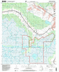
1998 Map of Humphreys
USGS Topo · Published 2000About this map
Mandalay National Wildlife Refuge dominates the southern reaches of this Louisiana landscape, where the Intracoastal Waterway cuts through an intricate network of marshes and open water like Lake Hatch. The region is defined by a dense industrial footprint of petroleum extraction, with extensive areas designated as the Orange Grove Oil and Gas Field and Hollywood Oil and Gas Field, marked by numerous drill holes and gas wells. To the north, the terrain transitions to the agricultural and residential corridors along Bayou Black, where the Southern Pacific railroad follows the natural curves of the waterway.
Find a feature on this map
42 named features on this map. Tap any name to fly to it.
Don’t see what you’re looking for? This feature index may not catch every label — zoom into the map to look around manually.
Map Details
Editions of this 1998 Humphreys Map
This is the sole edition of this map. No revisions or reprints were ever made.
Other maps of this area

1892 · Gibson
USGS Topo · 1:62,500

1892 · Houma
USGS Topo · 1:62,500

1894 · Bayou De Large
USGS Topo · 1:62,500

1894 · Dulac
USGS Topo · 1:62,500

1897 · Gibson
USGS Topo · 1:62,500

1932 · Houma SW
USGS Topo · 1:31,680

1932 · Houma NW
USGS Topo · 1:31,680

1935 · Theriot
USGS Topo · 1:31,680

1935 · Lake Gero
USGS Topo · 1:31,680

1935 · Lake Penchant
USGS Topo · 1:31,680