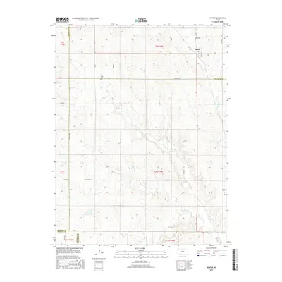
2015 Map of Hunter
USGS Topo · Published 2015About this map
Hunter serves as the central hub of this north-central Kansas landscape, situated near the convergence of four county lines: Osborne, Mitchell, Russell, and Lincoln. The terrain is defined by the dendritic drainage patterns of the Spillman Creek system, including the N Br Spillman Cr and S Br Spillman Cr, which carve through the plains. For those tracing family history, the map identifies three distinct burial sites: Greenwood Union Cem north of town, Elm Creek Cem to the west, and Spillman Cem to the southeast. The section-line road network, including the Mitchell Co Rd and Ash Grove Rd, illustrates the enduring grid of agricultural land division that has shaped this region since settlement.
Find a feature on this map
37 named features on this map. Tap any name to fly to it.
Don’t see what you’re looking for? This feature index may not catch every label — zoom into the map to look around manually.
Map Details
Editions of this 2015 Hunter Map
This is the sole edition of this map. No revisions or reprints were ever made.
Other maps of this area

1894 · Beloit
USGS Topo · 1:125,000

1896 · Osborne
USGS Topo · 1:125,000

1955 · Beloit
USGS Topo · 1:250,000

1959 · Beloit
USGS Topo · 1:250,000

1962 · Vesper
USGS Topo · 1:24,000

1963 · Sylvan Grove
USGS Topo · 1:24,000

1967 · Hunter
USGS Topo · 1:24,000
1968 · Ash Grove
USGS Topo · 1:24,000
1978 · Tipton
USGS Topo · 1:24,000
1978 · Lucas
USGS Topo · 1:24,000