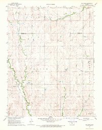
1968 Map of Ash Grove
USGS Topo · Published 1969About this map
The Blue Hills define the northern reaches of this north-central Kansas landscape, where the Atchison Topeka and Santa Fe railroad line follows the winding course of Bacon Creek toward the small settlement of Ash Grove. This late 1960s survey captures a transition between the elevated uplands and the fertile creek bottoms that supported early homesteads and communities. Several rural landmarks highlight the area's genealogical depth, including Bethany Ch and a series of burial grounds such as Patterson Cem and Spillman Cem. The map illustrates a network of townships including Orange and Battle Creek, with traditional transit routes like the north-south Trail connecting the drainage of Rock Creek in the north to Little Timber Creek in the south. The prevalence of Gravel Pits alongside these watercourses points to the local material extraction that supported the region's road infrastructure.
Find a feature on this map
22 named features on this map. Tap any name to fly to it.
Don’t see what you’re looking for? This feature index may not catch every label — zoom into the map to look around manually.
Map Details
Editions of this 1968 Ash Grove Map
This is the sole edition of this map. No revisions or reprints were ever made.
Other maps of this area

1894 · Beloit
USGS Topo · 1:125,000

1955 · Beloit
USGS Topo · 1:250,000

1959 · Beloit
USGS Topo · 1:250,000

1962 · Vesper
USGS Topo · 1:24,000

1962 · Lincoln
USGS Topo · 1:24,000

1963 · Sylvan Grove
USGS Topo · 1:24,000

1967 · Hunter
USGS Topo · 1:24,000

1968 · Beloit SW
USGS Topo · 1:24,000

1968 · Lincoln NW
USGS Topo · 1:24,000
1978 · Tipton
USGS Topo · 1:24,000