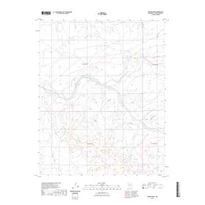
2023 Map of Hunter Wash
USGS Topo · Published 2023About this map
Chaco River and the winding De-na-zin Wash define this desert landscape in San Juan County, illustrating the intricate drainage patterns of the Colorado Plateau. The area is characterized by a sparse network of county and service roads that provide access across the high-desert terrain. These routes, including Co Rd 8860 and Indian Svc Rte 7060, reflect the modern infrastructure supporting local travel and land management in this rural section of New Mexico. The geography is shaped by the interplay between the dry riverbeds and the topographic relief of the surrounding badlands and mesas, where natural drainages dictate the path of human transit. The presence of service roads like Co Rd 8850 suggests the ongoing importance of access for resource management and local residents within the checkerboard boundaries of the region.
Find a feature on this map
12 named features on this map. Tap any name to fly to it.
Don’t see what you’re looking for? This feature index may not catch every label — zoom into the map to look around manually.
Map Details
Editions of this 2023 Hunter Wash Map
This is the sole edition of this map. No revisions or reprints were ever made.
Other maps of this area

1889 · Chaco
USGS Topo · 1:250,000

1892 · Chaco
USGS Topo · 1:250,000

1927 · Sulphur Spring
USGS Topo · 1:96,000

1928 · Kirtland
USGS Topo · 1:125,000

1932 · Kirtland
USGS Topo · 1:125,000

1954 · Shiprock
USGS Topo · 1:250,000

1958 · Shiprock
USGS Topo · 1:250,000

1959 · Shiprock
USGS Topo · 1:250,000
1966 · Tanner Lake
USGS Topo · 1:24,000
1966 · Alamo Mesa West
USGS Topo · 1:24,000