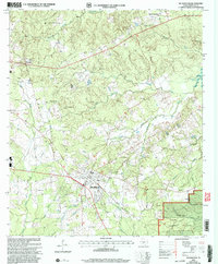
2003 Map of Huntington
USGS Topo · Published 2004About this map
Huntington serves as the central hub of this East Texas landscape, situated at the intersection of a developing road network just west of the Angelina National Forest. The map documents a community deeply rooted in its local geography, where dozens of small creeks like Buck Creek and Odell Creek drain toward the Sam Rayburn Reservoir in the east. The density of small family and community burial grounds, such as Traweek Cem and Jonesville Cem, suggests a long history of rural settlement patterns that predated the modern town layout. The landscape is further defined by its timber and resource history, evidenced by the Lowery Sawmill Road and various Gravel Pits. Educational and religious life is anchored by landmarks like Rocky Hill Sch and Little Flock Ch, which remain key identifiers for local genealogists and historians tracing the social fabric of Angelina County during this era.
Find a feature on this map
37 named features on this map. Tap any name to fly to it.
Don’t see what you’re looking for? This feature index may not catch every label — zoom into the map to look around manually.
Map Details
Editions of this 2003 Huntington Map
This is the sole edition of this map. No revisions or reprints were ever made.
Other maps of this area

1931 · Zavalla
USGS Topo · 1:62,500

1932 · Manning
USGS Topo · 1:62,500

1949 · Lufkin
USGS Topo · 1:62,500

1949 · Platt
USGS Topo · 1:24,000

1949 · Lufkin
USGS Topo · 1:24,000

1949 · Huntington
USGS Topo · 1:24,000

1950 · Platt
USGS Topo · 1:24,000

1950 · Lufkin
USGS Topo · 1:24,000

1950 · Redland
USGS Topo · 1:24,000

1950 · Huntington
USGS Topo · 1:24,000