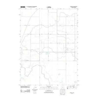
2012 Map of Huntley
USGS Topo · Published 2012About this map
Horse Cr meanders through this Goshen County landscape, defining the local topography and drainage patterns in a region shaped by agricultural irrigation. The presence of the E Goshen Hole Ditch illustrates the vital role of water management in this Wyoming prairie, where a grid of rural roads like Road 157 N and Co Rd-169 provides access to isolated homesteads and ranching operations. The small settlement of Holly and the Hillview Home facility stand as modest human landmarks amidst the expansive open range. This 2012 survey by the U.S. Geological Survey captures the quiet persistence of these rural Wyoming communities, documenting the essential intersections of water rights and land use in the early 21st century.
Find a feature on this map
33 named features on this map. Tap any name to fly to it.
Don’t see what you’re looking for? This feature index may not catch every label — zoom into the map to look around manually.
Map Details
Editions of this 2012 Huntley Map
This is the sole edition of this map. No revisions or reprints were ever made.
Other maps of this area

1896 · Patrick
USGS Topo · 1:125,000

1899 · Goshen Hole
USGS Topo · 1:125,000

1954 · Torrington
USGS Topo · 1:250,000

1954 · Cheyenne
USGS Topo · 1:250,000

1958 · Cheyenne
USGS Topo · 1:250,000

1958 · Torrington
USGS Topo · 1:250,000

1960 · Huntley
USGS Topo · 1:24,000

1960 · Hawk Springs
USGS Topo · 1:24,000

1960 · Lyman
USGS Topo · 1:24,000
1960 · Duroc
USGS Topo · 1:24,000