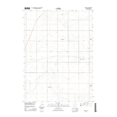
2015 Map of Huntley
USGS Topo · Published 2015About this map
The settlement of Huntley serves as the focal point for this landscape in the southeastern corner of Goshen County. This agricultural area is defined by a rigid grid of rural routes, including Road 50 and Road 54, and the presence of critical irrigation infrastructure. To the northeast, Katzen Reservoir Number 3 provides a significant water source for the surrounding fields, while the East Goshen Hole Ditch and Horse Cr traverse the southern and western portions of the quadrangle. The map reveals the organized township and range system common to the Wyoming plains, with the central village showing a small concentration of structures near Broadway St. This layout highlights the intersection of natural drainage and man-made water management systems that support the high plains farming and ranching economy.
Find a feature on this map
24 named features on this map. Tap any name to fly to it.
Don’t see what you’re looking for? This feature index may not catch every label — zoom into the map to look around manually.
Map Details
Editions of this 2015 Huntley Map
This is the sole edition of this map. No revisions or reprints were ever made.
Other maps of this area

1896 · Patrick
USGS Topo · 1:125,000

1899 · Goshen Hole
USGS Topo · 1:125,000

1954 · Torrington
USGS Topo · 1:250,000

1954 · Cheyenne
USGS Topo · 1:250,000

1958 · Cheyenne
USGS Topo · 1:250,000

1958 · Torrington
USGS Topo · 1:250,000

1960 · Huntley
USGS Topo · 1:24,000

1960 · Hawk Springs
USGS Topo · 1:24,000

1960 · Lyman
USGS Topo · 1:24,000
1960 · Duroc
USGS Topo · 1:24,000