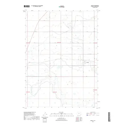
2018 Map of Huntley
USGS Topo · Published 2018About this map
Huntley sits at the center of this Goshen County landscape, where the high plains of eastern Wyoming meet the agricultural systems of the North Platte Valley. The terrain is defined by the winding course of Horse Cr and the engineering of the East Goshen Hole Ditch, which reflects the region's long-standing reliance on irrigation for ranching and farming. A regular grid of section lines and county roads, such as Co RD 139 and RD 56, organizes the territory, intersected by the diagonal route of Us 85 in the northwest. Distinctive local names like Lariat Loop and RD 53 D provide specific touchpoints for researchers tracing property lines or regional travel patterns. The map documents a sparsely populated but highly structured landscape of township and range boundaries, from t23n r62w to t22n r60w, at the close of the 2010s.
Find a feature on this map
36 named features on this map. Tap any name to fly to it.
Don’t see what you’re looking for? This feature index may not catch every label — zoom into the map to look around manually.
Map Details
Editions of this 2018 Huntley Map
This is the sole edition of this map. No revisions or reprints were ever made.
Other maps of this area

1896 · Patrick
USGS Topo · 1:125,000

1899 · Goshen Hole
USGS Topo · 1:125,000

1954 · Torrington
USGS Topo · 1:250,000

1954 · Cheyenne
USGS Topo · 1:250,000

1958 · Cheyenne
USGS Topo · 1:250,000

1958 · Torrington
USGS Topo · 1:250,000

1960 · Huntley
USGS Topo · 1:24,000

1960 · Hawk Springs
USGS Topo · 1:24,000

1960 · Lyman
USGS Topo · 1:24,000
1960 · Duroc
USGS Topo · 1:24,000