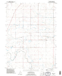
1990 Map of Huntley
USGS Topo · Published 1995About this map
Huntley and the nearby settlement of Holly anchor this portion of Goshen County, defined by a complex hydraulic landscape of irrigation and drainage infrastructure. The map reveals the critical importance of water management in the region, featuring an extensive network of ditches such as the Katzer Main Drain and its various branches, alongside the Springer Main Aqueduct. These engineered systems support the agricultural viability of the land surrounding Horse Creek, which winds across the lower portion of the sheet. To the south, the Laramie Fort Canal runs parallel to the creek, while the presence of a Flowing Well and a Gravel Pit indicates local reliance on groundwater and geological resources. Hillview Home stands as a notable landmark in this rural landscape, which is further interconnected by a subsurface Pipeline and a series of siphons and laterals that dictate the distribution of water across the plains.
Find a feature on this map
18 named features on this map. Tap any name to fly to it.
Don’t see what you’re looking for? This feature index may not catch every label — zoom into the map to look around manually.
Map Details
Editions of this 1990 Huntley Map
This is the sole edition of this map. No revisions or reprints were ever made.
Other maps of this area

1896 · Patrick
USGS Topo · 1:125,000

1899 · Goshen Hole
USGS Topo · 1:125,000

1954 · Torrington
USGS Topo · 1:250,000

1954 · Cheyenne
USGS Topo · 1:250,000

1958 · Cheyenne
USGS Topo · 1:250,000

1958 · Torrington
USGS Topo · 1:250,000

1960 · Huntley
USGS Topo · 1:24,000

1960 · Hawk Springs
USGS Topo · 1:24,000

1960 · Lyman
USGS Topo · 1:24,000
1960 · Duroc
USGS Topo · 1:24,000