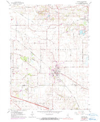
1978 Map of Huntley
USGS Topo · Published 1991About this map
The village of Huntley sits at the intersection of rural agriculture and expanding regional infrastructure in this late 1970s survey. The landscape is defined by the Kishwaukee River and its South Branch, which cut through the townships of Coral, Grafton, and Seneca. A prominent grid of family-named roads, such as Hemmingson Road and Frohling Road, connects outlying farms to the central rail hubs. The Chicago and North Western and Chicago Milwaukee St Paul and Pacific railroads illustrate the importance of these lines to the local economy before the dominance of the Northwest Tollway. Smaller community markers, including St Marys Ch, the adjacent St Marys Cem, and the Grange Hall, provide essential touchpoints for genealogists tracing the social and spiritual fabric of McHenry County and Kane County during this era of transition.
Find a feature on this map
42 named features on this map. Tap any name to fly to it.
Don’t see what you’re looking for? This feature index may not catch every label — zoom into the map to look around manually.
Map Details
Editions of this 1978 Huntley Map
This is the sole edition of this map. No revisions or reprints were ever made.
Other maps of this area

1925 · Elgin
USGS Topo · 1:62,500

1926 · Mc Henry
USGS Topo · 1:62,500

1932 · Harvard
USGS Topo · 1:48,000

1937 · Harvard
USGS Topo · 1:62,500

1938 · Genoa
USGS Topo · 1:62,500

1940 · Elgin
USGS Topo · 1:62,500

1944 · McHenry
USGS Topo · 1:62,500

1954 · Rockford
USGS Topo · 1:250,000

1955 · Rockford
USGS Topo · 1:250,000

1958 · Rockford
USGS Topo · 1:250,000