
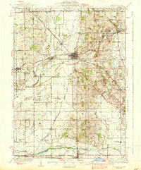
1937 Map of Harvard
USGS Topo · Published 1937About this map
The Chicago and Northwestern railroad lines define the landscape of this region during the 1930s, converging at the town of Harvard. This survey documents a dense network of rural infrastructure along the Illinois-Wisconsin border, where township life revolves around small school districts and farming hamlets. Named schools like Burr Oak Sch and Mokeler Sch are scattered across Chemung and Dunham townships, reflecting the localized social structure of the era. To the south, the Kishwaukee River flows through Marengo, a significant hub for this agricultural and rail corridor. The map preserves the exact locations of burial grounds such as Mt Auburn Cem and Oakwood Cem, providing a precise record for genealogists. From the settlements of Capron and Garden Prairie in the west to the tiny community of Big Foot Prairie on the state line, the map illustrates the transition from mid-century rail-side commerce to a landscape dominated by the Piscasaw Creek and Rush Creek drainages.
Find a feature on this map
71 named features on this map. Tap any name to fly to it.
Don’t see what you’re looking for? This feature index may not catch every label — zoom into the map to look around manually.
Map Details
Editions of this 1937 Harvard Map
2 editions found
Other maps of this area

1893 · Delavan
USGS Topo · 1:62,500

1893 · Shopiere
USGS Topo · 1:62,500

1893 · Geneva
USGS Topo · 1:62,500

1904 · Lake Geneva
USGS Topo · 1:62,500

1906 · Lake Geneva
USGS Topo · 1:62,500

1918 · Belvidere
USGS Topo · 1:62,500

1918 · Kirkland
USGS Topo · 1:62,500

1925 · Elgin
USGS Topo · 1:62,500

1926 · Mc Henry
USGS Topo · 1:62,500

1932 · Harvard
USGS Topo · 1:48,000