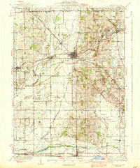
1937 Map of Harvard
USGS Topo · Published 1937About this map
Harvard emerges as the central rail hub of McHenry County on this 1930s-era survey, where the Chicago and Northwestern RR creates a complex network of transportation through the landscape. The surrounding agricultural townships, including Alden, Dunham, and Hartland, are densely dotted with rural schoolhouses that serve as markers of the local community structure of the day. Named for early families and local landmarks, schools such as Burr Oak Sch, Stone Sch, and Mokeler highlight a vanished era of localized education.
Find a feature on this map
102 named features on this map. Tap any name to fly to it.
Don’t see what you’re looking for? This feature index may not catch every label — zoom into the map to look around manually.
Map Details
Editions of this 1937 Harvard Map
2 editions found

Other maps of this area

1893 · Delavan
USGS Topo · 1:62,500

1893 · Shopiere
USGS Topo · 1:62,500

1893 · Geneva
USGS Topo · 1:62,500

1904 · Lake Geneva
USGS Topo · 1:62,500

1906 · Lake Geneva
USGS Topo · 1:62,500

1918 · Belvidere
USGS Topo · 1:62,500

1918 · Kirkland
USGS Topo · 1:62,500

1925 · Elgin
USGS Topo · 1:62,500

1926 · Mc Henry
USGS Topo · 1:62,500

1932 · Harvard
USGS Topo · 1:48,000