
1918 Map of Belvidere
USGS Topo · Published 1918About this map
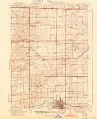
Belvidere and its surrounding townships in Boone and Winnebago counties appear here just as the first World War drew to a close. The landscape is defined by a dense network of over thirty named schoolhouses, such as Red Brick School, Quailtrap School, and Sunnyside School, reflecting the era's decentralized rural education system. The Kishwaukee River snakes through the southern portion of the map near the Fairgrounds, while the Chicago and Northwestern railroad and the Belvidere Electric line anchor the region's transport and utility infrastructure. Cultural anchors like the Scotch Church and Scotch Cemetery near Argyle provide specific points of interest for genealogists tracing early Scottish settlement patterns in Northern Illinois. From the Wisconsin border down to the Boone County Home, this survey documents a productive agricultural prairie at its peak of rail-dependent development.
Find a feature on this map
82 named features on this map. Tap any name to fly to it.
Don’t see what you’re looking for? This feature index may not catch every label — zoom into the map to look around manually.
Map Details
Editions of this 1918 Belvidere Map
This is the sole edition of this map. No revisions or reprints were ever made.
Historical Maps of Rockford Through Time
Featured Locations
- Beloit, WI
- Loves Park, IL
- Rockford, Rockford Township
- Machesney Park, Harlem Township
- Belvidere, Belvidere Township