
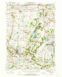
1944 Map of McHenry
USGS Topo · Published 1958About this map
Woodstock and the surrounding townships in McHenry County are shown here during a period of transition, following a 1944 revision of earlier 1920s surveys. The landscape is defined by the heavy presence of the Chicago and Northwestern railroad, which links established villages like Hebron and Richmond to the broader regional economy. The rural character is punctuated by an extraordinary density of neighborhood schoolhouses, including the Lyons School, Queen Anne School, and Stones Corner School, reflecting a time when education was strictly localized to small district buildings.
Find a feature on this map
66 named features on this map. Tap any name to fly to it.
Don’t see what you’re looking for? This feature index may not catch every label — zoom into the map to look around manually.
Map Details
Editions of this 1944 McHenry Map
2 editions found
Other maps of this area

1893 · Delavan
USGS Topo · 1:62,500

1893 · Silver Lake
USGS Topo · 1:62,500

1893 · Geneva
USGS Topo · 1:62,500

1904 · Lake Geneva
USGS Topo · 1:62,500

1906 · Silver Lake
USGS Topo · 1:62,500

1906 · Lake Geneva
USGS Topo · 1:62,500

1920 · Grays Lake
USGS Topo · 1:62,500

1923 · Grays Lake
USGS Topo · 1:62,500

1923 · Barrington
USGS Topo · 1:62,500

1925 · Elgin
USGS Topo · 1:62,500