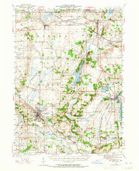
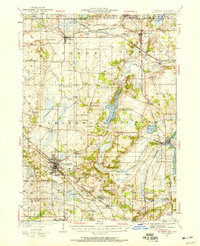
1944 Map of McHenry
USGS Topo · Published 1965About this map
Woodstock and McHenry anchor this 1944 revision of a 1924 survey, showcasing a landscape of dense rural school districts and maturing rail corridors. The Chicago and Northwestern railroad tracks cut a diagonal path through the terrain, connecting established agricultural hubs like Hebron and Richmond to the larger industrial markets. This era precedes the post-war suburban boom, depicting a region defined by small crossroad settlements and named country schools such as the Stones Corner School and Keystone School. Natural and man-made water features, including the sprawling Wonder Lake and the Fox River, reveal the area's early recreational and industrial utility. Smaller hamlets like Solon Mills and Terra Cotta appear in their mid-century state, providing a clear view of local infrastructure before the expansion of the modern highway system.
Find a feature on this map
67 named features on this map. Tap any name to fly to it.
Don’t see what you’re looking for? This feature index may not catch every label — zoom into the map to look around manually.
Map Details
Editions of this 1944 McHenry Map
2 editions found
Other maps of this area

1893 · Delavan
USGS Topo · 1:62,500

1893 · Silver Lake
USGS Topo · 1:62,500

1893 · Geneva
USGS Topo · 1:62,500

1904 · Lake Geneva
USGS Topo · 1:62,500

1906 · Silver Lake
USGS Topo · 1:62,500

1906 · Lake Geneva
USGS Topo · 1:62,500

1920 · Grays Lake
USGS Topo · 1:62,500

1923 · Grays Lake
USGS Topo · 1:62,500

1923 · Barrington
USGS Topo · 1:62,500

1925 · Elgin
USGS Topo · 1:62,500