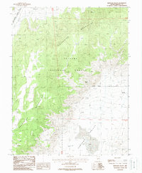
1988 Map of Huntoon Valley
USGS Topo · Published 1988About this map
The Excelsior Mountains dominate this high-desert terrain within the Toiyabe National Forest of Mineral County. This 1980s provisional study records a landscape defined by its isolation and limited water sources, such as Granite Spring and Government Well. The mapping of numerous Prospects and Adits throughout the mountain range suggests a history of mineral exploration that persists even as the region was further sectioned by a Restricted Access Area in the northwest. To the east, the flat expanse of Huntoon Valley contrasts with the surrounding peaks, providing a level corridor for travel. The presence of Cow Camp at the valley's edge indicates the continued use of this remote Nevada interior for ranching, while a network of 4wd tracks serves as the primary means of navigating between Whisky Flat and the mountain passes.
Find a feature on this map
16 named features on this map. Tap any name to fly to it.
Don’t see what you’re looking for? This feature index may not catch every label — zoom into the map to look around manually.
Map Details
Editions of this 1988 Huntoon Valley Map
This is the sole edition of this map. No revisions or reprints were ever made.
Other maps of this area

1909 · Hawthorne
USGS Topo · 1:250,000

1911 · Hawthorne
USGS Topo · 1:250,000

1915 · Hawthorne
USGS Topo · 1:250,000

1948 · Walker Lake
USGS Topo · 1:250,000

1955 · Powell Mtn
USGS Topo · 1:62,500

1957 · Walker Lake
USGS Topo · 1:250,000

1958 · Huntoon Valley
USGS Topo · 1:62,500

1962 · Walker Lake
USGS Topo · 1:250,000

1964 · Walker Lake
USGS Topo · 1:250,000
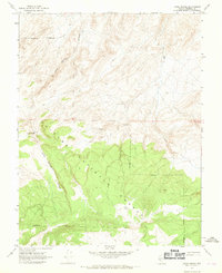
1967 · Jacks Spring
USGS Topo · 1:24,000