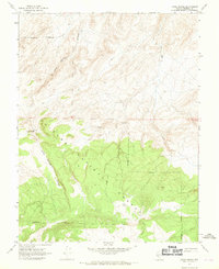
1967 Map of Jacks Spring
USGS Topo · Published 1969About this map
Toiyabe National Forest dominates the southern half of this Nevada landscape, where the high desert terrain transitions into the steep, wooded slopes of the mineral-rich range. The topography is defined by the prominent Jacks Spring Canyon, a geological drainage that carves a path through the center of the sheet. Human presence in this isolated environment is minimal, centered around Jacks Spring and a nearby Cabin in the western reaches. A network of Jeep Trails provides the only access through the backcountry, following the natural contours of the mountain ridges. These primitive routes and the specific placement of springs suggest a landscape shaped by early ranching or prospecting utility, where reliable water sources were the primary anchor for movement and temporary habitation.
Find a feature on this map
11 named features on this map. Tap any name to fly to it.
Don’t see what you’re looking for? This feature index may not catch every label — zoom into the map to look around manually.
Map Details
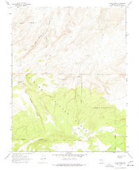
Editions of this 1967 Jacks Spring Map
2 editions found
Other maps of this area

1909 · Hawthorne
USGS Topo · 1:250,000

1911 · Hawthorne
USGS Topo · 1:250,000

1914 · Mt. Morrison
USGS Topo · 1:125,000

1915 · Hawthorne
USGS Topo · 1:250,000

1917 · White Mountain
USGS Topo · 1:125,000

1947 · Mariposa
USGS Topo · 1:250,000

1948 · Walker Lake
USGS Topo · 1:250,000

1948 · Mariposa
USGS Topo · 1:250,000

1957 · Walker Lake
USGS Topo · 1:250,000

1957 · Mariposa
USGS Topo · 1:250,000