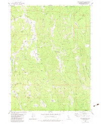
1982 Map of Hupa Mountain
USGS Topo · Published 1983About this map
Hoopa Valley Indian Reservation lands dominate the eastern portion of this Humboldt County terrain, where high ridges and deep creek drainages define the landscape during the early 1980s. The map illustrates a complex network of 4WD trails and small meadow-clearings known locally as prairies, such as Barber Prairie, Flyette Prairie, and Studhorse Prairie. This nomenclature suggests a history of grazing or seasonal upland use within the Six Rivers National Forest. Small points of development like the Green Point Sch near Beaver Flat and the settlement at Stover along Redwood Creek provide evidence of isolated community hubs. Water sources are abundant, with Lacks Creek and the North Fork Pasture Creek carving through the steep topography of Pine Ridge and Beaver Ridge. The presence of several gravel pits and named crossings like Kings Crossing underscores the practical infrastructure of this timber and ranching country.
Find a feature on this map
53 named features on this map. Tap any name to fly to it.
Don’t see what you’re looking for? This feature index may not catch every label — zoom into the map to look around manually.
Map Details
Editions of this 1982 Hupa Mountain Map
This is the sole edition of this map. No revisions or reprints were ever made.
Other maps of this area

1915 · Big Bar and Vicinity
USGS Topo · 1:250,000

1922 · Korbel
USGS Topo · 1:62,500

1922 · China Flat
USGS Topo · 1:62,500

1925 · Hoopa
USGS Topo · 1:125,000

1945 · Coyote Peak
USGS Topo · 1:62,500

1945 · Blue Lake
USGS Topo · 1:62,500

1948 · Weed
USGS Topo · 1:250,000

1950 · Weed
USGS Topo · 1:250,000

1951 · Blue Lake
USGS Topo · 1:62,500

1952 · Willow Creek
USGS Topo · 1:62,500