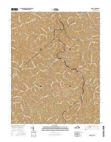
2016 Map of Hurley
USGS Topo · Published 2016About this map
Knox Creek and its many winding tributaries define the settlement patterns along the Kentucky Virginia border in Buchanan County. The landscape is marked by deep hollows and narrow valleys, where small communities like Hurley, Argo, and Kelsa are situated along winding routes such as State Rte 697 and Hurley Rd. The area's genealogical history is well-preserved through numerous family-named burial sites, including Dotson Cem, Mounts Cem, and Belcher Cem, often located on high ground overlooking the creek forks. The map reveals the intricate network of local roads and creek branches, from Pounding Mill Cr in the east to Left Fork Hurricane Cr in the northwest, illustrating how the topography of Sulphur Knob and High Knob has historically shaped transportation and habitation in this coal-country region.
Find a feature on this map
118 named features on this map. Tap any name to fly to it.
Don’t see what you’re looking for? This feature index may not catch every label — zoom into the map to look around manually.
Map Details
Editions of this 2016 Hurley Map
This is the sole edition of this map. No revisions or reprints were ever made.
Other maps of this area

1886 · Grundy
USGS Topo · 1:125,000

1887 · Warfield
USGS Topo · 1:125,000

1890 · Grundy
USGS Topo · 1:125,000

1891 · Tazewell
USGS Topo · 1:125,000

1891 · Oceana
USGS Topo · 1:125,000

1891 · Warfield
USGS Topo · 1:125,000

1892 · Grundy
USGS Topo · 1:125,000

1893 · Oceana
USGS Topo · 1:125,000

1895 · Tazewell
USGS Topo · 1:125,000

1897 · Tazewell
USGS Topo · 1:125,000