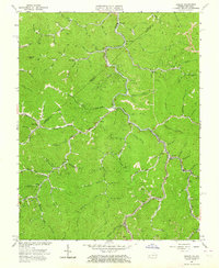
1963 Map of Hurley
USGS Topo · Published 1964About this map
The winding course of Knox Creek dictates the layout of human life along the border of Virginia and Kentucky in the early 1960s. This survey records the industrial and social infrastructure of the central Appalachian coalfields, where the Norfolk and Western railroad snakes through deep hollows to serve settlements like Hurley, Kelsa, and Argo. The landscape is a complex network of resource extraction and local community, indicated by the numerous gas wells, coal mines, and a large strip mine positioned along the ridges.
Find a feature on this map
82 named features on this map. Tap any name to fly to it.
Don’t see what you’re looking for? This feature index may not catch every label — zoom into the map to look around manually.
Map Details
Editions of this 1963 Hurley Map
2 editions found
Other maps of this area

1886 · Grundy
USGS Topo · 1:125,000

1887 · Warfield
USGS Topo · 1:125,000

1890 · Grundy
USGS Topo · 1:125,000

1891 · Tazewell
USGS Topo · 1:125,000

1891 · Oceana
USGS Topo · 1:125,000

1891 · Warfield
USGS Topo · 1:125,000

1892 · Grundy
USGS Topo · 1:125,000

1893 · Oceana
USGS Topo · 1:125,000

1895 · Tazewell
USGS Topo · 1:125,000

1897 · Tazewell
USGS Topo · 1:125,000