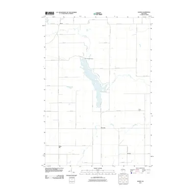
2010 Map of Huron
USGS Topo · Published 2010About this map
Otter Lake dominates the central landscape of this Chippewa County region, shaped by the Otter Lake 2WP315 Dam. The surrounding terrain is defined by a network of waterways, including the winding Wolf River to the south and Otter Creek which feeds into the lake from the north. Small rural settlements and intersections like Huron, Brownville, and Junction provide anchor points for the agricultural and wooded lands, connected by a rigid grid of roads such as County Hwy-G and Skyline Dr. In the eastern portion of the map, the Gilman Lookout Tower stands near the edge of the quadrangle, overlooking the drainages of the Wolf River and Little Otter Creek. The map details a landscape where water management and rural homesteading intersect, providing a clear record of the area's geography at the start of the 2010s.
Find a feature on this map
47 named features on this map. Tap any name to fly to it.
Don’t see what you’re looking for? This feature index may not catch every label — zoom into the map to look around manually.
Map Details
Editions of this 2010 Huron Map
This is the sole edition of this map. No revisions or reprints were ever made.
Other maps of this area

1951 · Cornell
USGS Topo · 1:62,500

1951 · Gilman
USGS Topo · 1:62,500

1952 · Cadott
USGS Topo · 1:62,500

1952 · Stanley
USGS Topo · 1:62,500

1953 · Eau Claire
USGS Topo · 1:250,000

1953 · Rice Lake
USGS Topo · 1:250,000

1958 · Eau Claire
USGS Topo · 1:250,000

1959 · Rice Lake
USGS Topo · 1:250,000

1964 · Eau Claire
USGS Topo · 1:250,000
1973 · Colburn
USGS Topo · 1:24,000