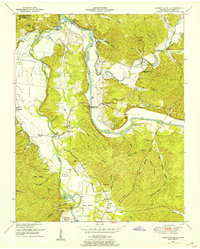
1950 Map of Hurricane Mills
USGS Topo · Published 1953About this map
Kentucky Lake and the winding Duck River define this landscape in Humphreys County, where the Tennessee Valley Authority’s mid-century water management transformed the region. The settlement of Hurricane Mills sits at the confluence of Hurricane Creek and the river, anchored by the Hurricane Mills School and nearby Anderson Cem. The map reveals a deeply dissected terrain of hollows—such as Voorhies Hollow and Roberts Hollow—that separate the high ground of Walker Ridge from the fertile bottomlands of Cherry Bottom and Parks Bottom. Genealogists will find a dense network of family-named burial grounds, including Williams Cem, Shannon Cem, and Walker Cem, scattered across the ridges. Evidence of early infrastructure remains visible through river crossings like Tanksley Bridge and Martin Ford Bridge, alongside the Tennessee National Migratory Wildlife Refuge at the lake's edge.
Find a feature on this map
83 named features on this map. Tap any name to fly to it.
Don’t see what you’re looking for? This feature index may not catch every label — zoom into the map to look around manually.
Map Details
Editions of this 1950 Hurricane Mills Map
2 editions found
Other maps of this area

1936 · Gorman
USGS Topo · 1:24,000

1936 · Hurricane Mills
USGS Topo · 1:24,000

1936 · Coble
USGS Topo · 1:24,000

1936 · Daniels Landing
USGS Topo · 1:24,000

1936 · Bucksnort
USGS Topo · 1:24,000

1936 · Johnsonville
USGS Topo · 1:24,000

1936 · Lobelville
USGS Topo · 1:24,000

1936 · Waverly
USGS Topo · 1:24,000

1936 · Hustburg
USGS Topo · 1:24,000

1949 · Daniels Landing
USGS Topo · 1:24,000