1943 Map of Hyde Park
USGS Topo · Published 1943About this map
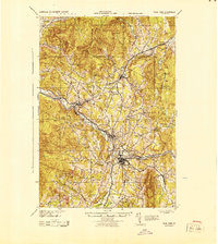
The Lamoille River carves a deep valley through this mid-century Vermont landscape, serving as the industrial and social spine for settlements like Johnson, Morrisville, and Hyde Park. The map reveals a dense network of rural education, marking dozens of specific schoolhouses including the Davis Neighborhood Sch, Tyndall Sch, and Edson Hill Sch. These schools, often situated at lonely crossroads or near family farm clusters, provide a clear view of the dispersed population centers during the 1920s and 1940s.
Find a feature on this map
105 named features on this map. Tap any name to fly to it.
Don’t see what you’re looking for? This feature index may not catch every label — zoom into the map to look around manually.
Map Details
Editions of this 1943 Hyde Park Map
This is the sole edition of this map. No revisions or reprints were ever made.
Other maps of this area

1919 · Montgomery
USGS Topo · 1:62,500

1919 · Montpelier
USGS Topo · 1:62,500

1920 · Franklin Pond
USGS Topo · 1:62,500

1920 · Montgomery
USGS Topo · 1:62,500

1920 · Irasburg
USGS Topo · 1:62,500

1921 · Richmond
USGS Topo · 1:48,000

1921 · Montpelier
USGS Topo · 1:62,500

1922 · Enosburg Falls
USGS Topo · 1:48,000

1923 · Irasburg
USGS Topo · 1:48,000

1924 · Camels Hump
USGS Topo · 1:62,500