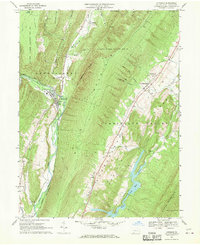
1967 Map of Hyndman
USGS Topo · Published 1970About this map
Hyndman occupies a narrow valley floor where the Baltimore and Ohio and Penn Central rail lines converge along the banks of Wills Creek. This late 1960s landscape in southern Bedford County is defined by the steep parallel ridges of Wills Mountain and Evitts Mountain, which channel settlement into the linear corridors of the Cumberland Valley. The map reveals a rural infrastructure of family and community landmarks, from the Fellowship and Union Cems near Centerville to the isolated Bethel Ch tucked into Oster Hollow. To the south, the waters of Lake Koon and Lake Gordon dominate the valley between the ridges, while large tracts of State Game Lands No 48 and State Game Lands No 104 preserve the high ground of Johnston Ridge and Tiguenour Ridge.
Find a feature on this map
47 named features on this map. Tap any name to fly to it.
Don’t see what you’re looking for? This feature index may not catch every label — zoom into the map to look around manually.
Map Details
Editions of this 1967 Hyndman Map
Other maps of this area

1898 · Frostburg
USGS Topo · 1:62,500

1899 · Flintstone
USGS Topo · 1:62,500

1900 · Flintstone
USGS Topo · 1:62,500

1901 · Frostburg
USGS Topo · 1:62,500

1908 · Frostburg
USGS Topo · 1:62,500

1923 · Berlin
USGS Topo · 1:48,000

1927 · Hyndman
USGS Topo · 1:62,500

1929 · Berlin
USGS Topo · 1:62,500

1931 · Hyndman
USGS Topo · 1:62,500

1944 · Hyndman
USGS Topo · 1:62,500
Featured Places
- Hyndman, PA
- Cumberland Valley Township, PA
- Harrison Township, PA
- Southampton Township, PA
- Londonderry Township, PA