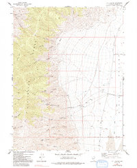
1972 Map of I X L Canyon
USGS Topo · Published 1992About this map
The Stillwater Range dominates the western half of this 1972 survey, casting a sharp profile over the Dixie Valley (Depression) to the east. Evidence of mining activity is scattered across the high terrain, notably at Silver Hill (Site) and the Creore Mine located near Willow Canyon. The landscape is etched with steep drainages like James Canyon and Rough Creek Canyon, which funnel toward the valley floor where a network of unpaved tracks, including Settlement Road and Cattle Road, suggests a history of ranching and remote habitation. The presence of Ruins and multiple Mines and Prospects speaks to a period of mineral exploration and hard-scrabble settlement in this part of Churchill County. Water remains a critical and scarce resource, marked by isolated points such as Mud Spring and West Job Canyon Springs tucked into the mountain folds.
Find a feature on this map
37 named features on this map. Tap any name to fly to it.
Don’t see what you’re looking for? This feature index may not catch every label — zoom into the map to look around manually.
Map Details
Editions of this 1972 I X L Canyon Map
2 editions found
Other maps of this area

1908 · Carson Sink
USGS Topo · 1:250,000

1910 · Carson Sink
USGS Topo · 1:250,000

1957 · Reno
USGS Topo · 1:250,000

1959 · Reno
USGS Topo · 1:250,000

1960 · Reno
USGS Topo · 1:250,000

1966 · Dixie Hot Springs
USGS Topo · 1:62,500

1969 · Cox Canyon
USGS Topo · 1:24,000

1969 · Table Mtn
USGS Topo · 1:24,000
1969 · Lone Rock SE
USGS Topo · 1:24,000
1972 · I X L Canyon
USGS Topo · 1:24,000