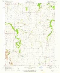
1962 Map of Iantha
USGS Topo · Published 1963About this map
The St Louis - San Francisco railroad cuts a diagonal path across this Barton County landscape, anchoring the settlement of Iantha in the southeast and the smaller hamlet of Wimmer to the west. In the early 1960s, the rural economy of this region was defined by a mix of agriculture and industry, evidenced by the numerous Strip Mine excavations scattered throughout the terrain. Significant water features like the East Fork Dry Wood Creek and its tributaries, including Wood Creek and Little Wood Creek, drain the area, while Logue Lake provides a localized landmark near the center of the survey.
Find a feature on this map
20 named features on this map. Tap any name to fly to it.
Don’t see what you’re looking for? This feature index may not catch every label — zoom into the map to look around manually.
Map Details
Editions of this 1962 Iantha Map
This is the sole edition of this map. No revisions or reprints were ever made.
Other maps of this area

1884 · Fort Scott
USGS Topo · 1:125,000

1886 · Nevada
USGS Topo · 1:125,000

1886 · Joplin
USGS Topo · 1:125,000

1886 · Fort Scott
USGS Topo · 1:125,000

1886 · Carthage
USGS Topo · 1:125,000

1893 · Fort Scott
USGS Topo · 1:125,000

1894 · Nevada
USGS Topo · 1:125,000

1894 · Joplin
USGS Topo · 1:125,000

1894 · Carthage
USGS Topo · 1:125,000

1945 · Pittsburg
USGS Topo · 1:62,500